A growing low-pressure system east of Florida, which might become tropical later this week, poses a storm threat to many Gulf Coast states.
Why It Matters
The Atlantic hurricane season started on June 1. The most recent storm was Tropical Storm Chantal, which formed earlier this month.
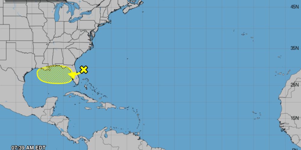
Meteorologists at the National Hurricane Center are now watching a low-pressure system east of Florida, which has a low chance of becoming a tropical storm within a week. If it forms, the storm will be named Dexter.
The development comes as meteorologists forecast an above-average hurricane season in the Atlantic this year.
What to Know
As of Monday, the disturbance east of Florida had a 10% probability of becoming tropical in the next 48 hours and a 30% chance of doing so within the next seven days.
The forecast also stated that environmental conditions in the Gulf were conducive to tropical development, implying that ocean temperatures are high enough and that there are no significant winds that could destabilize the system.
The low-pressure system is forecast to move west or west-northwest into the Gulf’s northeastern and north-central regions by mid- to late-week.
AccuWeather’s chart shows “widespread” rains spanning the whole state of Florida, southern Georgia, coastal Alabama, coastal Mississippi, and southeastern Louisiana between Monday and Thursday. Rainfall levels might be between 2 and 4 inches.
The risk of localized rainfall stretches as far north as North Carolina.
In addition to heavy rain, dangerous surf conditions, such as rip currents, are forecast throughout the shore.
What Happens Next
After the present low-pressure system passes, AccuWeather meteorologists predict that “vast areas of dust from the Sahara Desert as well as disruptive winds” will prevent future tropical development near the United States for the foreseeable future.